


Texas airspace planning and forecasting to combat encroachment on military preparedness
Texas airspace planning and forecasting to combat military encroachment
The 10,000-foot view of Texas land with its reaching piney woods, sprawling metroplexes, diverse rivers and streams, miles of pastureland, peaks and plateaus, county seats and desert oases lends a quick explanation as to why our state is teeming with growth year over year—realistically, month over month.
One of the first things you learn about Texas is that the majority of those views are privately-owned, dotted by more fence lines than any other state, and a large percentage of that ownership is stewarded as open space or working lands providing ecosystem services, like clean air, water, extreme weather mitigation and natural pollination to the rest of the state and beyond.
The second facet you learn is that growth and open space are generally not compatible; here, you find the middle ground of Texas. In this space, no matter the type of landowner or manager, stakeholders work constantly to build awareness of potential conflicts and to create opportunities for proactive planning and forecasting; in this space, we anticipate encroachment.
Land owned by the Department of Defense
Honing in on the types of landowners and land uses in Texas, encroachment, or the incompatible uses of land, air, water and other resources, can take on different forms. As one of the largest landowners in Texas and the U.S., the Department of Defense (DoD) owns 1.5 million acres of Texas land dedicated to the prosperity and sustainment of military operations.
NRI penned a previous article discussing encroaching development spurred by population growth and energy industry expansion breaking down the details on how the military retains ownership and manages land inside their fence lines. Above the ground, DoD utilizes an expansive patchwork of military airspace routes across the state. These land and air spaces are critical to the military readiness mission yet are often compromised by competing needs of civilians and private industry, as the state continues to make room for more renewable energy production, population growth, and the increasingly prevalent, multi-billion-dollar companies now calling Texas home.
Adding to the toolbox for military planners
Finding middle ground between state stakeholders and crafting collaborative solutions and tools to address Texas’ challenging land use needs have been a focal point of NRI’s work for many years. In 2019, our team developed the Texas Early Notification Tool (TENT), a web tool designed to help wind energy developers identify areas of potential conflict with military assets, namely aviation operations, and to facilitate early communication with military stakeholders. While TENT’s public-facing use has been successful, there remained a need for planning tools specifically designed for military operations planners and airspace managers.
Fast forward to today, NRI’s latest web tool, the Texas Airspace Planning and Forecasting Tool, provides a comprehensive solution for planners. Employing easy-to-navigate functionality, the tool combines those military installation fence lines on the ground and airspace boundaries over head with forecasted land development data up to year 2050. Military-centric managers can visualize future land use change that highlights where potential incompatible development, such as urban or wind energy expansion, may cross paths with military aviation test and training sites and routes; thus, empowering planners to proactively develop long-term strategies and solutions to combat potential land use conflicts.
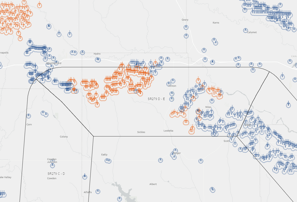 TAPFT screenshot showing what projected wind development looks like on the map.
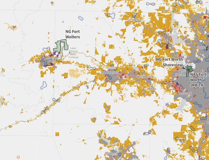 Screenshot from TAPFT showing expanding development from the DFW metroplex.
Multidimensional efforts of land management
Continuing on with this toolbox analogy, landownership and management come with multi-faceted compartments and layers whether we’re working to solve complex challenges for private landowners, the military, producers, local organizations and others.
Ultimately, where we can collaborate and be creative in our solutions for landowners to keep open spaces healthy, we’re contributing to a much larger story of conservation, a 10,000-foot view where we come back to this realization that the land and air across our landscape provides our very ecosystem.
Learn More

Military land compatibility
Protecting military land while ensuring compatibility with surrounding areas and strategic conservation efforts through the use of web-based mapping tools
Authors


Recent Posts

June 23, 2025
Working Lands, Wildlife: A Wild Goose Chase Win


May 19, 2025
My Quest to Find the Elusive Texas Alligator Lizard

May 12, 2025