


Q&A with Texan by Nature: Meet the Texas A&M Natural Resources Institute
This interview was originally shared by Texan by Nature as part of their conservation partner Q&A series.
Texan by Nature (TxN) is proud to partner with 110+ conservation organizations working to positively benefit Texas’ natural resources and communities through innovative approaches. TxN accelerates conservation by bringing together organizations and businesses through programs that convene diverse stakeholders and catalyze science-based conservation efforts.
The Texas A&M Natural Resources Institute is grateful beyond measure for the team behind Texan by Nature and their ability to empower organizations and offer solutions and partnerships that are changing the way we see conservation possibilities. We’re honored to be a Conservation Partner and invite you to learn more about how they connect groups with the resources and relationships needed to accelerate impact.
---
We recently had a chance to sit down with TxN and answer a few questions that really had us digging deep and swinging wide to describe the work that comes out of the institute conducted by the brilliant minds under our roof. It was an electrifying process.
We’re are educators as much as we are researchers learning; we’re passionate about the future as much as we can be pessimists about the ways we’ve previously failed; we’re locals as much as we are international; we’re stewards of discovery and of the landscapes and wildlife out here—and we have yet to find a more diverse crew of sleeves-rolled coffee-drinkers, perpetually leaning into the reality of landscape-scale conservation led by the constant ripple of positive actions of urban and rural communities across the state and beyond.
Without further ado…
---
Q: Tell us about the Natural Resources Institute and its mission.
A: The Texas A&M Natural Resources Institute (NRI) is made up of 80+ researchers, scientists, extension agents, and policy experts stationed in 12 states across the U.S. who are all interested in promoting the value of land stewardship and wildlife conservation. Between our in-house expertise and our extensive partner network, we’re uniquely positioned to identify information gaps existing anywhere from natural resource policy to the knowledge base of private landowners. Our mission is to solve complex natural resource challenges through discovery, engagement, innovation, and land stewardship.
Q: What is the history of NRI?
A: Officially staffed in 2007, NRI became a grant-funded (public and private) natural resource research and extension unit, led by the Land Grant University mission under Texas A&M University. As a member of the state’s land-grant system, our initiatives are founded on the basic need to enrich Texas with comprehensive agricultural and life sciences knowledge and services to restore connections among people, agriculture, food, science, and the economy.
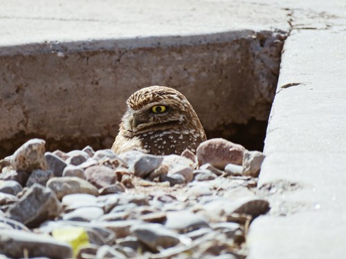
NRI researchers constructed and installed artificial Burrowing Owl nests at Holloman Air Force Base. The operation included a small chemistry lesson on diluent choice for 4,4 methylene diphenyl diisocyanate, the primary ingredient used in creating the natural rock roadbed in the artificial nests!
Q: How do you work to achieve your mission and who is your audience?
A: NRI leads three major focus areas—wildlife, military, and private lands.
Through our Private Lands and Trends hub, our Land Trends group builds and uses geospatial tools and landscape planning to support research and extension projects with accurate scientific data, while our Natural Resource Research group pursues findings and solutions to challenges regarding rangeland, avian, herpetology, mammalian and aquatic research. Here, we’re able to conduct research that addresses the current problems surrounding wildlife and habitat management and promotes their stewardship to landowners and policymakers.
In our Military Land Sustainability & Policy hub, we work to support military readiness and land stewardship through integrated management practices on military bases and through partnerships. The Wildlife Conservation & Policy Innovation team directs our threatened and endangered species work through the U.S. Fish and Wildlife Service (USFWS) and provides the U.S. Department of Defense (DoD) with natural resource program support. Our Installation Management crew conducts research and carries out responsibilities related to conservation practices on military bases and installations, supporting existing teams and personnel. To ensure we’re working across networks effectively, our Regional Planning & Partnerships leaders collaboratively drive initiatives like the Sentinel Landscapes Partnership, the Southeast Regional Partnership for Planning and Sustainability (SERPPAS) and the Readiness and Environmental Protection Integration (REPI) program protecting military missions by helping remove or avoid land-use conflicts near installations and addressing regulatory restrictions.
All of which continually feed our education and engagement programs for urban and rural communities at the forefront of conservation challenges—the key to stewardship in perpetuity.
---
We always say we’re where conservation and applied research meet. We work every day to stay ahead of some of the most complex natural resource concerns, but an immense part of what we do depends on thoughtful collaboration with other experts in the field. We thrive in this space where we’re able to positively impact entire ecosystems together and prove a return on investment for the people who benefit from open space and healthy working lands. It’s exhilarating to see this institute move when there’s a call and it’s even more exciting to get to tell our stories.
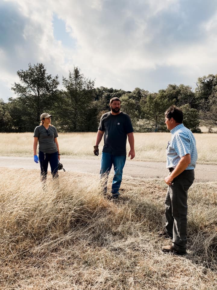

Working with our partners at Selah, Bamberger Ranch Preserve to demonstrate the value of prescribed fire on private lands through “Leopold Live!“.
Q: What are some examples of your projects or programs?
A: NRI is known for our ability to be nimble and to find the right expertise for the challenge in everything we do.
The Texas Land Trends project monitors the status and changes in land use, ownership size and land values of working lands. Research results are published as topic-based reports through txlandtrends.org, an award-winning interactive website. Users can also explore and query the data through the web-based mapping service right on the site. The project provides decision-makers and stakeholders with timely information to support the conservation and strategic planning of working lands within a spatially explicit context. Here’s a preview of a few tools we’ve developed through Texas Land Trends:
- Data Explorer: This tool allows users to curate land trend data based on location or interest. Custom data queries by users generate an output of summary statistics, which demonstrate land demographic data in three primary categories: land use, land values, and ownership. These data are displayed through interactive mapping, tables, graphs, and general text to allow unique visualization of occurring changes on the selected areas of interest.
- Texas Early Notification Tool (TENT): This tool allows users to create custom queries based on their area or areas of interest. If the area selected intersects a military asset notification area that warrants early notification, the tool will generate an output with the notification areas and associated point of contact information. These data are displayed through interactive mapping, tables, and general text.
- Readiness and Environmental Protection Integration Program (REPI): This tool provides users with GIS locations of all military installations nationwide with completed REPI transactions, along with relevant information and resources for these projects such as economic data and project profile pages. Custom query feature allows users to pull REPI data for multiple installations at the local-, state-, and regional-level.
- TxMAP: Over the last year, our geospatial analysis team ideated and developed a web-based desktop mapping application called TxMAP (sounds like tex-map) allowing users to see how the water, wildlife, military and demography data we use relates to the land around it. Readers can explore the data layers to answer questions and better visualize natural resources across Texas through boundaries and markups, and then publish and print a summary of their findings. Individualized map reports created in TxMAP can be used for policymakers, conservation organizations, state and federal agencies and private landowners and managers to give a comprehensive review of desired geospatial information.
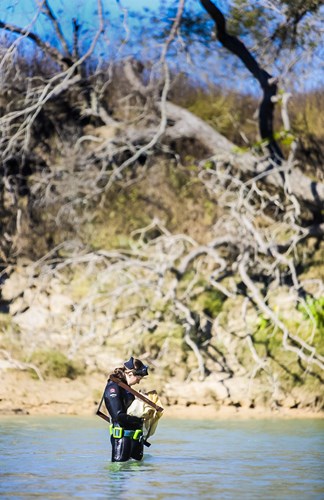
Through our Private Lands and Trends hub, bringing our geospatial, research and engagement experts together, the most recently pursued project in partnership with East Foundation, the Caesar Kleberg Wildlife Research Institute, Lindner Center for Conservation and Research of Endangered Wildlife at the Cincinnati Zoo, the University of Tennessee Comparative and Experimental Medicine Program and Center for Wildlife Health, Texas Parks and Wildlife Department, and the U.S. Fish and Wildlife Service, is a study of the viability of potential actions designed to establish a new population of ocelots (Leopardus pardalis) in South Texas to both help prevent their extirpation and increase their numbers in the U.S.
Through this project, officially called “Developing and Assessing Strategies for Reintroducing Ocelots to Historical Texas Habitat,” NRI and our partners are exploring the feasibility of reintroducing the endangered ocelot to a portion of their historical range in Texas that is distinct from known populations’ currently occupied habitat.
The project’s exploratory research efforts include:
- 1) assessments of where ecologically and socio-politically suitable ocelot habitat may occur in South Texas (and thus where possible reintroduction sites may occur);
- 2) the methods for sourcing individuals for an additional population of ocelots;
- 3) strategies for successfully releasing ocelots into the wild;
- 4) development of plans for the long-term management of reintroduced ocelots;
- and 5) determining the long-term viability of a reintroduced population given ecological constraints.
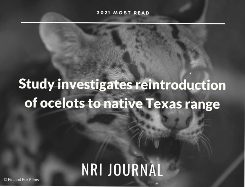
Seven partners are exploring the feasibility of reintroducing the endangered ocelot.
Another wildlife research and education-related project called The Reversing the Quail Decline Initiative was one of NRI’s most wide-reaching projects for six years and provided extension programming, research summaries, and other valuable resources to landowners who were interested in learning about or pursuing quail conservation on their property. We held the ever-popular QuailMasters programs to teach landowners all about native quail and the management of their habitat, gathered statewide population data through the Texas Quail Index, and shared blogs and videos that reached thousands of Texas viewers.
NRI also collaborates with the Texas Water Resources Institute (TWRI) on our freshwater mussel project where researchers study the biology, population distributions, and conservation statuses of declining freshwater mussel species. The research conducted in this lab helps promote aquatic ecosystem and species conservation and inform policymakers as to whether certain species should be listed for protection under the Endangered Species Act.

Since 2011, NRI’s freshwater mussel research program has provided information on mussel taxonomy, population distribution and ranges, and other science-based knowledge and solutions for state and federal natural resource agencies.
An ongoing project we mentioned earlier is the Sentinel Landscapes Partnership where NRI works with DoD who relies on critical land, air and sea space in which it can train troops and test vital weapon systems. These testing and training areas, once remote in location, now face increasing encroachment. Housing developments and schools built adjacent to installations pose safety concerns. Conversely, noise and dust from military training exercises are a nuisance to those same schools and housing developments. The Sentinel Landscapes Partnership is an innovative collaboration to promote compatible land use around important military facilities.
While large rural landscapes such as farms, ranches and forestland are vital to sustaining agricultural and timber productivity and protecting wildlife habitat, they are also good neighbors to military bases. Private landowners maintaining rural lands, in some cases for decades and without due recognition, have significantly contributed to the nation’s defense.
Through the Sentinel Landscapes Partnership, the U.S. Departments of Agriculture, the Interior and Defense are recognizing and incentivizing landowners to maintain working lands, undertake conservation practices that benefit wildlife habitat, and continue land-use practices that are compatible with the military’s mission.
NRI understands the unique relationship between natural resources and national defense and is assisting these departments in implementing sentinel landscapes. We provide management expertise in programs and policy development where national defense requirements and natural resource interests meet, especially as we consider DoD as one of the largest land managers in the U.S.
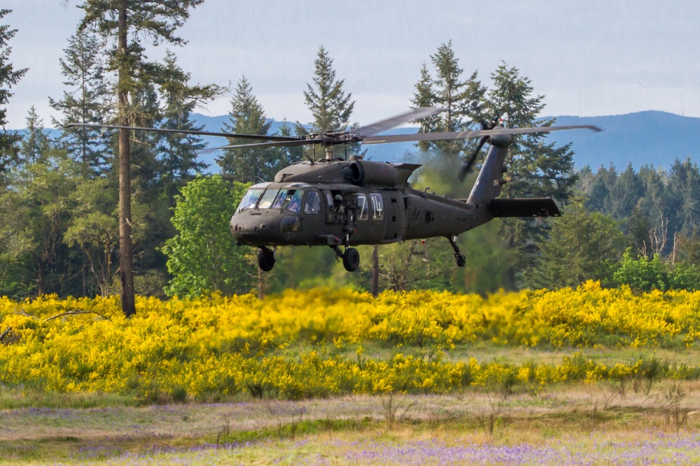

The Joint Base Lewis McChord (JBLM) Sentinel Landscape encompasses 63,000 acres of military training area, including over 7,000 acres of impact area, 86 ranges and mortar points, 13 drop zones, and two airfields. In addition, the sentinel landscape supports the majority of the remaining prairie habitat in the south Puget Sound.
Q: What are the ecological and economic benefits of your organization’s projects/programs?
A: Many of our programs directed at private landowners teach them how to implement conservation practices on their land. Healthy, biodiverse land not only creates valuable habitat for wildlife but increases the inherent value of the property. Our sentinel landscapes projects maintain the health of military lands and their neighboring rural lands, economically benefiting DoD by reducing the need to relocate military installations around sensitive species and reducing future land maintenance costs that may arise due to climate change or urban encroachment.
We also recently began practicing calculating the value of ecosystem services on conserved and managed lands, a term used to describe things like clean air and water, carbon sequestration and wildlife habitat that are necessary to live — essentially affirming the valuable public benefits of conserved open space and healthy land. For example, we discovered that the state taxpayers receive a 27:1 return on investment for conservation easements, where the state funds $4 million per biennium (since 2015) and the annual value of ag commodities, water regenerations and wildlife consumption tops $10 million on those same lands.
Q: Tell us about the future of NRI. Do you have any upcoming initiatives, exciting events, or challenges ahead?
A: Top of mind for everyone right now is our opportunity to collaborate, and even integrate in some regards, with the newly redesigned Department of Rangeland, Wildlife and Fisheries Management (RWFM) within the College of Agricultural & Life Sciences. Our director, Dr. Roel Lopez, recently accepted a dual appointment to serve as the department head for RWFM. We’ve worked closely with the department since our inception to ensure RWFM (previously Wildlife and Fisheries Sciences) students are granted access to real-world, contracted and field research experiences under PIs as they pursue their masters and doctoral degrees.
Through this collaboration, we’ve started to see opportunities for our project and service crossovers like geospatial services for extension specialists to help them solve challenges across the state on private land.
We are also currently hosting a live video series once a month on Facebook called Leopold Live! where we and experts from the Selah, Bamberger Ranch Preserve discuss practical wildlife and habitat management techniques and answer questions from viewers. Some of this season’s topics include using game cameras, supplemental water, and herbicides and brush management.
Q: How can people get involved with and learn more about NRI?
A: Our work focuses on connecting with landowners and managers, other researchers, students and conservation organizations. One of our ongoing goals is to make sure that research and insights end up where they can be used, rather than sitting on the proverbial shelf. We launched the seasonal NRI Sourcebook in 2020 where you can find the latest research and resources all in one place complete with abstracts and a brief demonstration of what the work means for conservation. We want readers to use the information, to dive into the research, and allow it to catalyze initiatives dependent on sound science.
Those interested can always follow us on social media (Instagram, Facebook, and Twitter) where we share our latest resources and updates. You can also sign up to receive our articles, editorial and think-pieces on Medium at https://tamu-nri.medium.com/.
Otherwise, reach out and drop me a line: brittany.wegner[@]ag.tamu.edu.
You can read the latest issue of the NRI Journal, as well as past issues, here.
Thanks for reading and supporting our work.
---
Texan by Nature is proud to partner with 105+ conservation organizations across Texas. Through our Conservation Partner network, we connect conservation organizations with the resources and relationships they need to extend their initiatives’ impact. Partner benefits include on-going features on social media, monthly media round-up, quarterly meetings, aggregated resources on fundraising, marketing/social media, and more.


Recent Posts


June 23, 2025
Working Lands, Wildlife: A Wild Goose Chase Win


May 19, 2025