

Featured Map: Land ownership types across the U.S.
Working lands, whether private or publicly owned provide substantial economic, ecological, and recreational resources across the U.S. Here in Texas, we often boast of being a “private land state”, meaning the majority of the land (~95%) is held in private ownership. Many may wonder how this came to be and if other states fall under similar ownership patterns. For this month’s Featured Map, we briefly explore the history of land settlement across the nation and demonstrate the unique ownership landscape that exists today.
Working · lands | n.
1 : privately owned farms, ranches and forests that produce food and fiber, support rural economies, and provide wildlife habitat, clean air and water, and recreational opportunities.
2 : lands that foster healthy environments, and support recreational and other intrinsic needs.
3 : 142 million acres in Texas under increasing land conversion pressure driven by rapid population growth, suburbanization, and rural development, creating implications for rural economies.
Starting in 1946 under the Truman Administration, the U.S. Department of the Interior’s Bureau of Land Management (formerly the General Land Office and the U.S. Grazing Service), began administering land on the basis of multiple-use (i.e., grazing, timber, recreation, etc.) and sustained yield, while also conserving natural, historical, and cultural resources. Early on, settlers were encouraged to head West with the lure of multiple homesteading acts, ensuring the transfer of public land to those who resided on and cultivated land after a period of time.
Eventually, these homesteading acts were repealed and a new policy of retaining public lands in Federal ownership was established with the Federal Land Policy and Management Act in 1976. As such, the majority of public lands in the U.S. are held in the western half of the country, where homesteading had less time to fully take hold, while privately owned working lands dominate the Great Plains and Midwest.

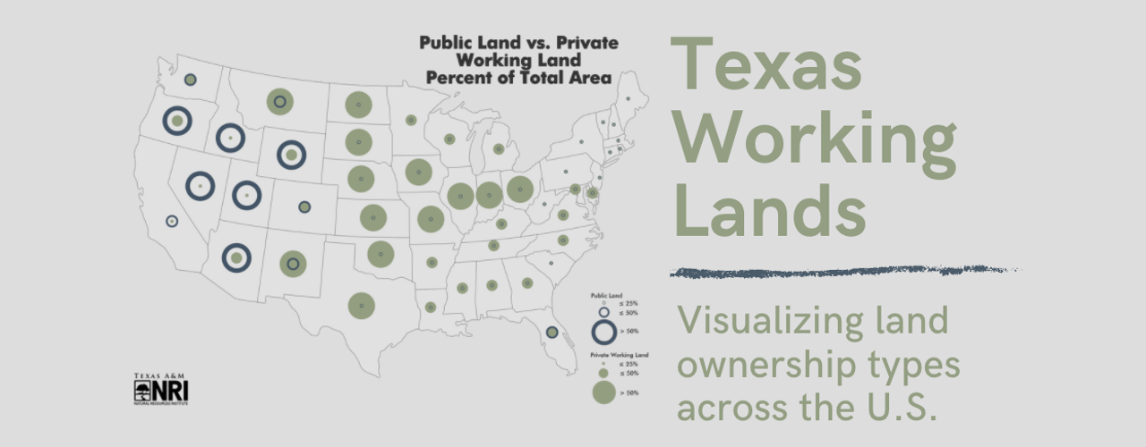
Figure: Privately owned working lands (shown in green) and public lands (shown in blue; includes both working and non-working lands) are displayed as a percent of total state area, helping paint a picture of land ownership across the U.S. See below for table for a breakdown of acreage by state and data sources.
Visualizing working lands and their ownership types across the country can help to highlight opportunities for strategically employing different land conservation and management approaches. While public-owned land is often mandated to uphold multiple-use and sustainability requirements, privately owned land management is often driven by the objectives of the private landowner, which are generally influenced by financial constraints and incentives. Protecting privately owned working lands and the ecological benefits they provide from land conversion and fragmentation, especially in majority private land states such as Texas, requires a different approach—one that takes individual landowner objectives and incentives into account and provides adequate support for land management goals.
Check out our latest Texas Farms and Ranch Lands Evaluation Report that highlights the state-funded program with the sole purpose of protecting public interests through conserving privately owned working lands.
Data Sources
Note: Public land and private working land datasets are independent of each other. State percentages cannot be combined to depict the state as a whole. Other land ownership types, such as privately owned non-working lands, are not included in this map.
Public Land: Public land including federal, state, and locally owned lands and also voluntarily provided private protected areas in 2018.
U.S. Geological Survey, Gap Analysis Project (GAP). 2018. Protected Areas Database of the United States (PADUS), Version 2.0. Combined Feature Class Native_Data_Set_Environment: Environment as of Metadata Creation: Microsoft Windows 10 (Build 7600); Esri ArcGIS 10.2.2 (Build 3552). <https://doi.org/10.5066/P955KPLE>.
Private working land: Private working lands, including all properties from which $1,000 or more of agricultural products were produced, sold, or normally would have been sold during the census year 2017.
U.S. Department of Agriculture, National Agricultural Statistical Service. 2020b. Census of Agriculture database. <https://www.quickstats.nass.usda.gov>.
Table: Breakdown of state privately owned working lands and public land, represented as acreage and as a percent of the state’s total landmass.

Learn More

Texas Land Trends
Informing private and public decision-makers about the status and trends of our state’s working lands
Authors


Recent Posts


June 23, 2025
Working Lands, Wildlife: A Wild Goose Chase Win


May 19, 2025