Map of the Month: Trends along Texas Borderlands
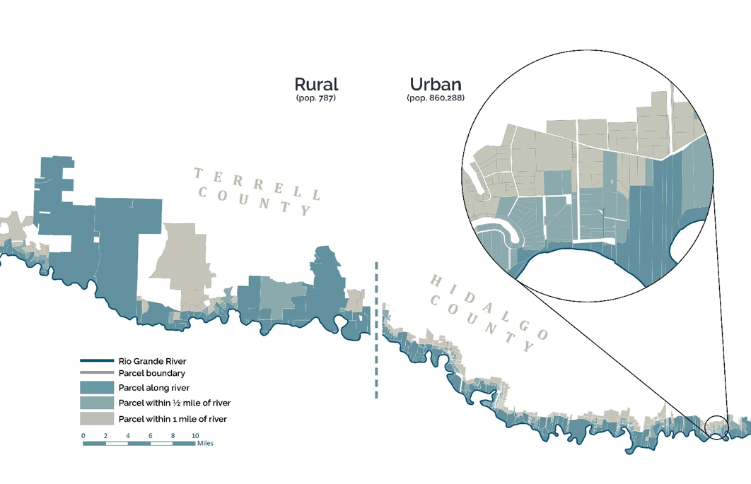

Land parcels in Terrell and Hidalgo Counties, 2018.
We’ve noticed a tendency in our Map of the Month articles—and you may have noticed, too—that always leads us back to writing about the unique history and deep heritage of Texas. Within the state’s constantly evolving landscapes and growing populations, it’s in the unseen spaces of wildlife monitoring and management where we focus the most. Recognizing our knack and appreciation for picking up true courses happening across Texas, we selected this month’s featured map from our latest Texas Land Trends publication Trends in Land Ownership Along Texas Borderlands.
In this publication, we discuss the U.S.-Mexico Borderlands, a distinctive region of the state that spans 1,254 miles. At one end lies the heavily populated Borderplex of El Paso-Juárez and the other Brownsville-Matamoros. In between these urban complexes you can expect to find a vast array of unique flora and fauna, both endangered and endemic to the region, and equally unique landscapes ranging from crawling deep canyons in the northern portion to mixed shrublands in the south. Similarly, the human settlement along the border along with the shapes and sizes of land parcels have been anything but homogeneous. But how did we get here?
Spurring back from the 1700s, Spanish Land Grants were distributed along the Rio Grande River to encourage new settlement. Generally, the land parcels were surveyed to conform to the needs of the area, for instance, the land in the southern region was surveyed into long, narrow tracts known as porcoines to allow water access to more residents. This was a necessity for the farming practices common in the area that depended upon irrigation. Further north, land parcels were surveyed into larger tracts to accommodate ranching operations that the arid climate would better support.
Natural growth and immigration of new residents since that time have contributed to a population expansion from around 107,000 to 2.5 million people in these counties since 1900, with the majority of growth seen in southern metroplex areas, especially the McAllen-Edinburg Mission metropolitan area. The land parcels in these areas have followed suit, expanding from about 31,000 in 1990 to around 1 million in 2018. Our featured map demonstrates the variability of land parcels between a low populated, northern rural county (Terrell) and a heavily populated, southern urban county (Hidalgo).
As populations continue to trend upwards, land parcels in these counties will subsequently continue to subdivide, with an expected outcome of land conversion from one land use to another (e.g., agricultural to residential) and the break-up of important rural, working lands. Additionally, stress on natural resources in heavily populated areas will surely increase, as described in our previous blog on freshwater mussels in the Rio Grande basin. Identifying counties where populations and land parcels are increasing, especially at accelerated rates, can help target where added natural resource management (e.g., conservation easements) may be most beneficial.
To see the full report, check out our Texas Land Trends website at txlandtrends.org!
Share this post
Authors

As a program manager for the Texas A&M Natural Resources Institute, Alison leads several initiatives spanning NRI’s programs including Private Lands & Trends and Military Land Sustainability & Policy. Her work foc…

Matt Crawford, a certified GIS professional with over two decades of experience, serves as the GIS Coordinator and has been with Texas A&M Natural Resources Institute since September 2013. Holding a master's degree in Ran…